

Hi All,
just checking the details on this trip.
Is it just one night? What route is everyone planning to take?
Cheers
Ray
McGillivray Pass
-
ANDYD
- Defender of the World
- Posts: 3077
- Joined: Tue Mar 09, 2004 10:45 pm
- Location: Sunny Steveston BC
McGillivray Pass
Hi Ray,
This trip was suggested at one of the meetings early in the year, we penciled it in on the calendar for July 17-18th.
There is not a whole lot known about the status of the trail but it is basically a horse trail that follows the McGillivray creek.
There are two options, a low road that follows the creek or a high road that run up higher.
It is expected to be fairly over grown and a challenging trail, we are not even sure if we are able to make it all the way through.
It starts just north of D'Arcy off the north side of Anderson Lake. It then runs through the valley heading NW until finaly getting to Gold Bridge on Carpenter Lake.
Not much is known about this trail so we welcome any past knowledge if anyone out there has been in this area.
Cheers,
Andy
-
ANDYD
- Defender of the World
- Posts: 3077
- Joined: Tue Mar 09, 2004 10:45 pm
- Location: Sunny Steveston BC
McGillivray Pass
Hi All,
This weekend we are planning on heading up to McGilliwray Pass.
For those who are not familiar with this area it is just a beautiful part of BC just north of Pemberton which is pretty much a remote wilderness area. The going is expected to be fairly challenging and expect some bushwacking / pinstriping at the very least.
If we don't make it though the Pass (good chance that we wont) then plan B is to try the Anderson Lake to Duffy Lake trail that follows Haylmore Creek. (pages 39-40 in your SW BC Back road mapbook).
For those leaving on Friday we are planning on camping at Spetch Creek rec site which is about 8km North of mount Currie. Anyone coming up on Saturday morning can meet us at Spetch Creek before 10am.
Plan on being back in Pemberton early sunday afternoon.
We will discuss more at meeting on Thursday, post up if you plan to come out or if you have any questions.
I will post the GPS co-ords of the campsite a little later,
Cheers,
Andy
-
discojonny
-
ANDYD
- Defender of the World
- Posts: 3077
- Joined: Tue Mar 09, 2004 10:45 pm
- Location: Sunny Steveston BC
McGillivray Pass
Hi Jonathon,
Good to hear your coming along. I will be bringing my younger son also.
cheers,
Andy
Good to hear your coming along. I will be bringing my younger son also.
cheers,
Andy
-
Doc Tari
I'm in for this run Andy and looking forward to the change of scenery. So far it looks like there's three of us, is no one else interested? The weather is going to perfect for wheeling/camping! Kris? Shawn? Bill? Bernie? Glen?
I'm not yet sure if I'll go up on Friday evening or Saturday morning, what are others planning?
Pete
I'm not yet sure if I'll go up on Friday evening or Saturday morning, what are others planning?
Pete
-
ANDYD
- Defender of the World
- Posts: 3077
- Joined: Tue Mar 09, 2004 10:45 pm
- Location: Sunny Steveston BC
McGillivray Pass trip report
Hi All,
Well, we didn't get far up McGillivray Pass, about 1/2km into the trail the small washout has turned into a huge washout and the river has reclaimed the road. Still passable on small quad or motor cycle it would take a day of road building to get a Land Rover through.
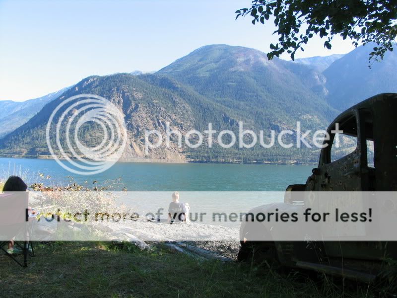
We diverted around Anderson Lake to Seton Portage, accross the dam and into the Lilloet area. Found some great trails that gave us some just amazing lookouts over the lakes and mountains including a run over Copper mountain that landed us on a nice secluded beach and camp site on Seton Lake.
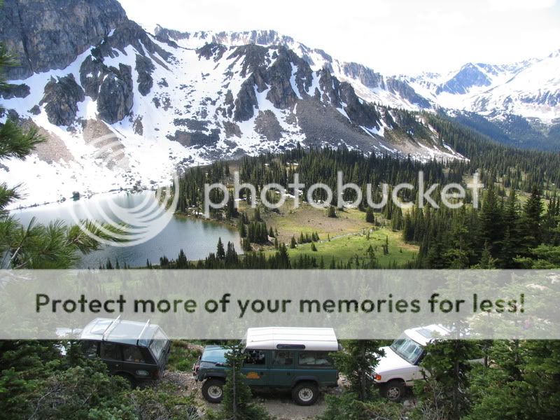
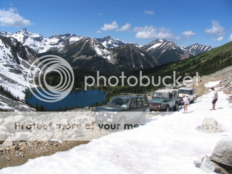
The following day we explored along Blowdown pass and up to the edge of the Stein Valley, found a little snow at near 7000ft when we were "on top of the world"
It was a spectacular weekend for camping up around the Pemberton area.
We managed to find some great new spots. Photos coming soon....
Cheers,
Andy
http://i439.photobucket.com/albums/qq11 ... 010070.jpg
Blowdown Pass to Stein Valley
http://i439.photobucket.com/albums/qq11 ... 010077.jpg
Blowdown Pass to Stein Valley
http://i439.photobucket.com/albums/qq11 ... 010041.jpg
Seton Lake (south East)[/img]
Well, we didn't get far up McGillivray Pass, about 1/2km into the trail the small washout has turned into a huge washout and the river has reclaimed the road. Still passable on small quad or motor cycle it would take a day of road building to get a Land Rover through.
We diverted around Anderson Lake to Seton Portage, accross the dam and into the Lilloet area. Found some great trails that gave us some just amazing lookouts over the lakes and mountains including a run over Copper mountain that landed us on a nice secluded beach and camp site on Seton Lake.
The following day we explored along Blowdown pass and up to the edge of the Stein Valley, found a little snow at near 7000ft when we were "on top of the world"
It was a spectacular weekend for camping up around the Pemberton area.
We managed to find some great new spots. Photos coming soon....
Cheers,
Andy
http://i439.photobucket.com/albums/qq11 ... 010070.jpg
Blowdown Pass to Stein Valley
http://i439.photobucket.com/albums/qq11 ... 010077.jpg
Blowdown Pass to Stein Valley
http://i439.photobucket.com/albums/qq11 ... 010041.jpg
Seton Lake (south East)[/img]
-
ANDYD
- Defender of the World
- Posts: 3077
- Joined: Tue Mar 09, 2004 10:45 pm
- Location: Sunny Steveston BC
Pemberton area run
Hi All,
Photos are now posted to the gallery for this run.
http://roverlanders.bc.ca/gallery/view_ ... y_2010_003
Cheers,
Andy
Photos are now posted to the gallery for this run.
http://roverlanders.bc.ca/gallery/view_ ... y_2010_003
Cheers,
Andy